
Quick note: the Jorrit project mentioned in earlier posts moves very slowly forward but in ways that just aren’t that interesting to show or talk about. It’s happening mostly in my brain.
About two months ago, I ran across some of Kev Polk’s ideas for Edenicity, a kind of city-scale permaculture design. In particular, what caught my attention was the idea of being able to integrate food production with the city proper, rather than having food produced in rural areas outside a city (or further!) and having to transport it in.
As I’ve been learning 3D modeling in Blender, I thought that might be a fun thing to model–maybe even turn it into a game-type environment by exporting into Unity. But it wasn’t until that last week or so that a bunch of pieces kind of fell into place and I knew how I was going to pull it off: I was going to reshape Seattle.
One of the structures Edenicity is formed around is a kind of fractal organization of space. The smallest chunk is called a “village,” akin to a neighborhood, but generally smaller and built to be reasonably self-contained and independent. In several places around Seattle there are experimental projects pushing toward sustainability, and I know of several specifically in the northern part of the city, so I decided to focus on the area of Northgate. It’s got multimodal transit at the Northgate Transit Center, there’s already a block that has some nice density plus mixed-use buildings around a lovely natural area, and other features that made it seem like a good place to start.
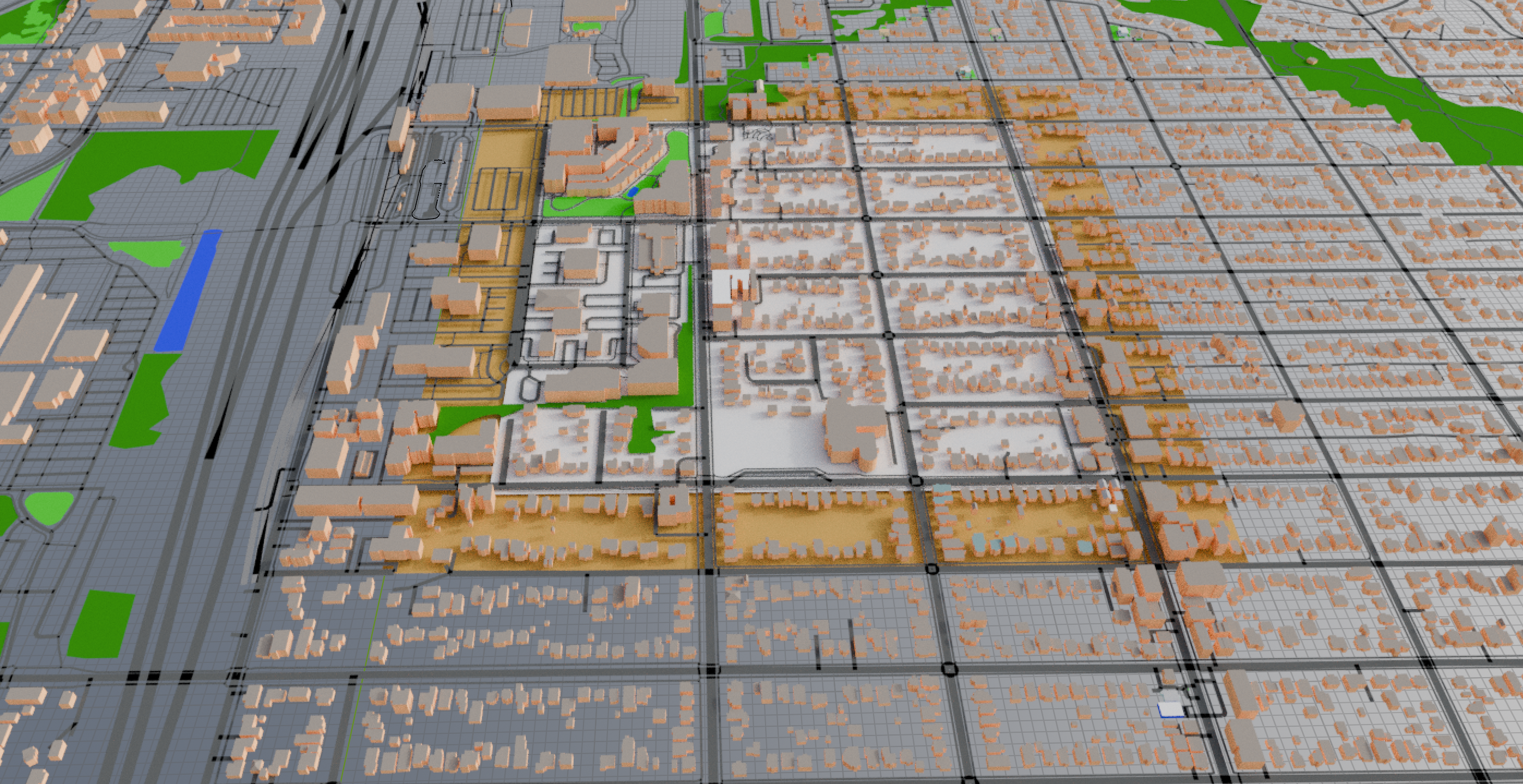
So, I imported a 6 kilometer square centered on the Northgate area to Blender using the Blosm (formerly Blender-OSM) addon. It’s kind of generic but detailed enough to have footpaths and even tiny buildings represented. Polk’s Edenicity villages are smaller than mine and his blocks are square. Seattle generally has 2-by-1 blocks, so I marked out 18 blocks as my first village: 3 long blocks wide, by 6 short blocks tall. This is marked in the image above with the white square at 625m per side. Around it is a band of about one short-block in golden yellow. We’ll get to that part eventually.
Making Assumptions
Next, I did a bunch of research and math to come up with reasonable assumptions. The median single family home in Seattle is pretty close to 2000 square feet, and occupied by 2.08 people, or close enough to 1000 square feet (93 square meters) per house-dwelling person.
The average apartment in Seattle is 659 square feet (61 square meters), but the national average is over 800 square feet (over 74 square meters). We have tiny apartments here. So my assumptions are that an apartment/condo is 75 square meters–since Blender uses metric by default. That gives apartment/condo dwellers the extra space of the national average, and for each single-family home I replace with higher density housing, I reserve 3 apartments for the 2 displaced people, which also gives the average house-dweller some extra room too. Everyone gets more square footage than average for Seattle right now.
I also noticed that my first village contained a school that in the real world serves about 400 students. It’s an elementary school, but I thought why not repurpose it for all grades (there’s a college just across the freeway to the west, so don’t need to worry about that age group). The under-18 population of Washington State is 21%, but Seattle is only 13%. I decided to go with assuming 20% of the humans in the village are under 18 to account for shifts back toward the state numbers, and at those children attend the school.
Oh, and I assumed that the whole city was more or less on board with my plans and would joyfully relocate according to my zoning whims. That was the only way to make this change with any sort of speed. Zoning can only do so much in a given length of time.
Phase 1: Consolidating Green
Assumptions in place, I got in my digital bulldozer to consolidate natural space and increase housing density. In each block I left any buildings that looked like they were big enough to be apartment complexes or condo buildings (I’m just going to say apartment from now on, but I’m not concerning myself with ownership structures for this.) Those buildings already have people living in them and they keep living in them.
Single family homes, however, all get removed and the 2 people each get “converted” into 3 apartment-equivalents. They stay on the block, and I mark the housing need as a negative number. For example, in the image below you can see an empty block labeled “-52” which is the number of 75 square-meter apartments I’d need to build to house all the people formerly living there. The math: there were an estimated 17 houses removed in this block = 34 people in houses x 1.5 apartments = 52; and 20% of 34 people = 7 children attending the school.
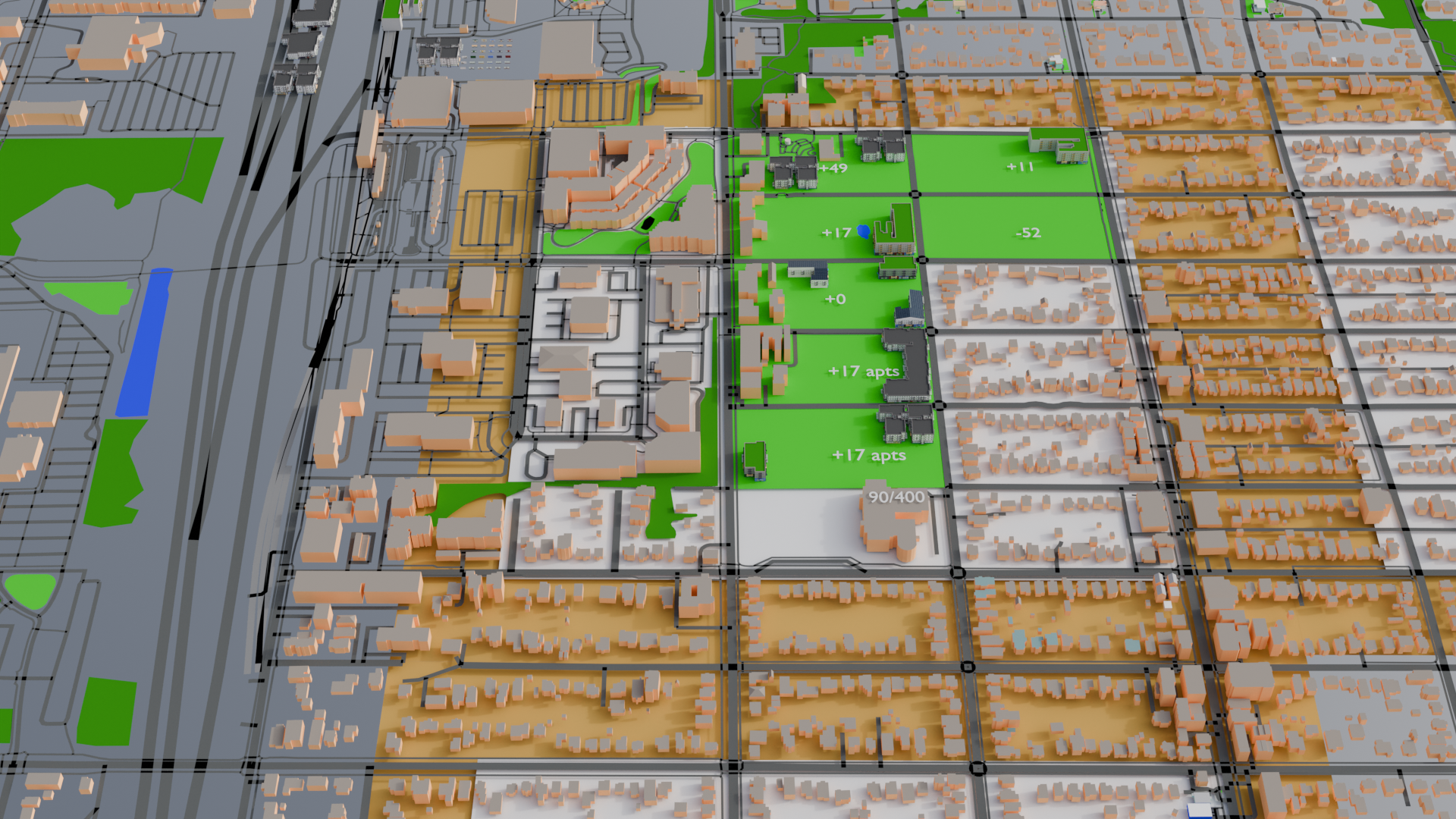
Once I placed the new buildings, based on area per floor, I could move those folks in. Any excess housing would be updated as a positive number, such as the blocks in the center column. The blocks that have been completed are green because I am assuming that park-like landscaping or community vegetable patch areas or food forests or other such community-supporting green space would be put in. This allows for greater chunks of greenery which is better for natural habitat, walking trails, controlling the heat island effect of cities, improves mental and emotional health of residents, and so forth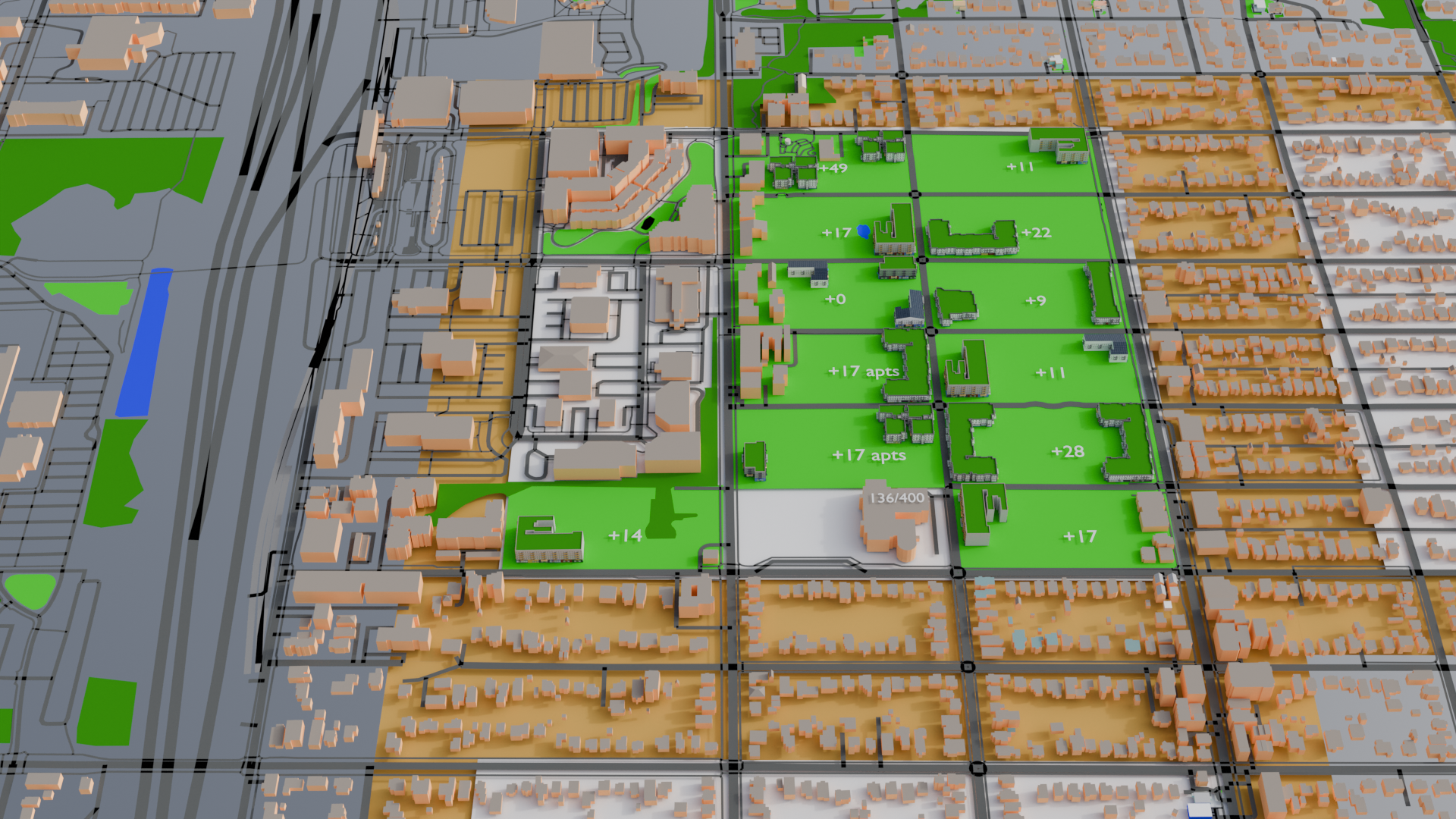
Once all of the housing has been dealt with, everyone in the village has a park just outside the door of their building, and probably a combination of solar power generation and fresh veggies growing on the building’s roof. On the ground floor of each building is retail, allowing for lots of small-scale daily-needs types of businesses to go in close to where everyone lives. But more on this in Phase 2 when I post it. There’s also over 212 extra apartments, or enough additional housing to move in over 70 additional single family homes into the village without constructing any more buildings.