
Previously, on Eco-ing Seattle…
In Phase 1, I took an 18-block space in Northgate and created what I’m now referring to as “Village N” by consolidating all the green space and converting single family homes into low-rise condos with more floor space on average for each person. Phase 2 did a similar thing to small retail and office space, moving them into the ground floor of the new condos and apartments, and converting their huge parking lot area into community parks. Phase 3 created a 1-block band of farmland around the village by moving those people and businesses into the excess spaces in the village area. And then Phase 4 zoomed out to look at the larger context of the village as part of a larger collection of 24 villages as a “town” with a town center, and roads and transportation within the town.
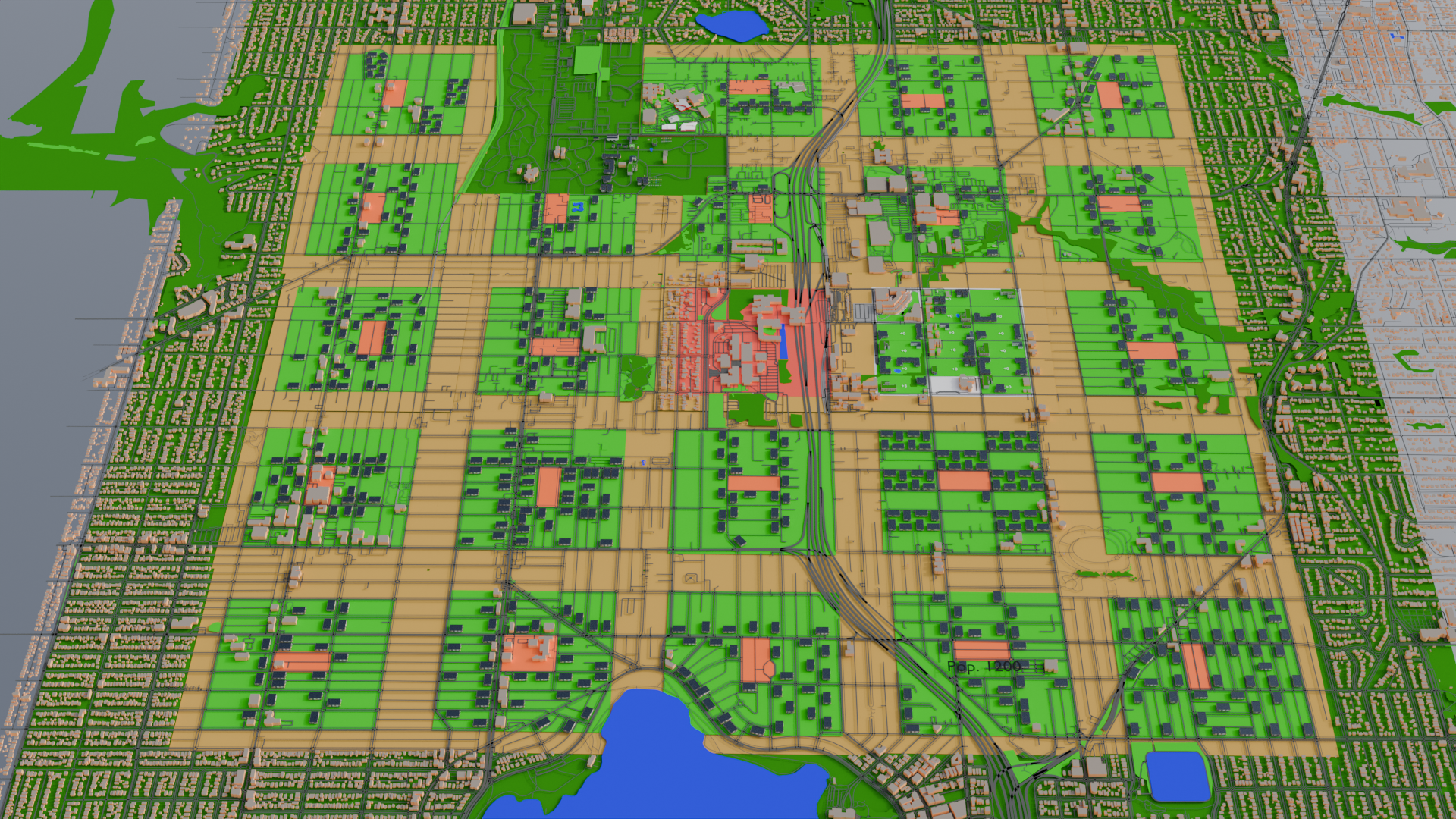
Converting the Town
To make the entire town, I did what I’d done in Village N to all of the villages in the town-level organization, just with a bit more abstraction. First, I defined areas and renamed them by letter, starting at Village A in the northwest corner, Village E in the northeast, Village M being the town center, and Villages U through Y along the southern border.
Then I estimated the population in single family homes (with a little bit of randomness skewed toward the high end added for good measure), gave each person 1.5 apartment-equivalents, left larger apartment buildings as they were, and built enough low rise mixed use apt/condo buildings as necessary to house everyone in the village and the farm band around it.
One thing I noticed as I did this was that each of these little micro-neighborhoods had quite a large variation in how many people lived there. Some only ended up with an estimated population of a few hundred, others with over 2000–again, just looking at single-family residents. This really had an impact on how many buildings I needed to add to each village.
A second thing I noticed was, well, the road grid was a lot more varied than it seemed at first. Block sizes were generally the same throughout, but lots of places had the long side of the block going north/south, while others were oriented east/west. There were lots of road that were not quite oriented to the compass directions, and some that just seemed to do whatever they wanted. This opened up the idea for me of building placement preferences.
As a result, I treated each village as if it had its own village council choosing where to put the buildings. Many went with a strategy of prioritizing buildings along the larger roads, clustered around the village center, or a combination of both. Some went with tight clusters of housing/business in order to maximize open space elsewhere in the village, while others went with an attempt at equidistant spacing so everyone had a similar amount of open space around the building where they lived.
I also adjusted the edges of each village slightly to match the road network. This meant that some villages ended up with a somewhat higher ratio of farmland, while others somewhat less. I also marked a block in reddish-orange near the center of each as the village center. This, too, varied a little based on the block size, location of larger roads, and so forth.
And I had to eliminate Village B entirely, since it would have been built on top of a cemetery, a veteran’s memorial, and the grave of one of the people sometimes credited with discovering gold and triggering the Yukon Gold Rush. Graves and some Seattle history probably shouldn’t knowingly have condos built on them. (I’ve probably built other stuff on more graves unknowingly, but I’m not aiming for perfect–just a reasonable model.)
Once that was done, I decreased the width of the roads as described in Phase 4. This has a slight effect of visually de-emphasizing roads, but I had still noticed that there were a lot of roads–particularly crisscrossing the farms. That wouldn’t do, so I kept roads that defined edges of villages, and at least one connecting village centers for the bus system. The rest of the roads through farmland were removed. This should improve efficiency and ease of farming, and route cars through more defined areas.
Oh, and I changed the roof textures to solar panels rather than rooftop gardens. No doubt if this were done in real life, there’d be some combination of both throughout the town. but it made the buildings easier to see if everything wasn’t some shade of green. Community gardens can happen at ground level, and more solar installations just make power more sustainable.
Town Center
I realized that I’d neglected the town center, which is in the location of Village M, marked in red in the center of the map. That is currently the location of North Seattle College, which is well enough, but I’m going to be building some additional buildings.
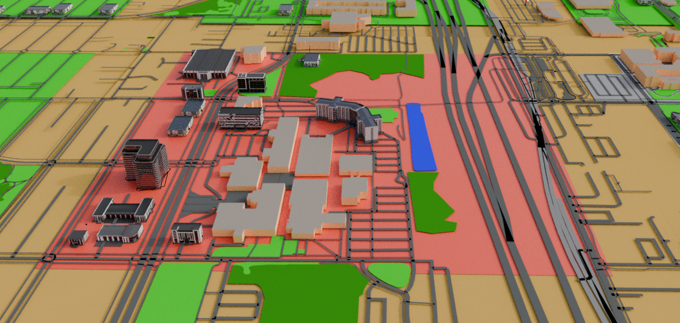
I started by moving the few houses into two apartment/condo buildings, which was more than enough housing for everyone. I kept the buildings of North Seattle College the way they are now, but added more amenities appropriate to the idea that they’d serve a larger region than just this village. I added another school building for under-18 students who need additional support or advanced programs, overflow students if a village school fills up, and so forth.
There’s an assembly hall for the meetings of the town council and others, located in the park at the north end. Heading east from there is a wheelchair accessible pedestrian pathway leads over the freeway to the train and bus hubs. This makes civic involvement more convenient and inclusive.
One block further on is a multiplex theater on the corner of Village N so that’s not really needed here.
I added a multistory medical center, a fairly large fire station, and multiple mid-rise office buildings (4 to 12 stories). And a sports complex for, you know, sportsing. Or whatever happens in one of those. (Not my thing, don’t @ me.)
For those following along in Blender, all these new buildings were free models in BlenderKit, all of which can be found by searching the models category for “facade.”
Could there be a shopping complex here, too? Yeah, probably, though most of the current Northgate Mall is located in Village I, which is about a 10 minute walk away, and this town center in particular has the freeway taking up almost a quarter of the space, so I figure that’s a good enough arrangement and shows how you don’t necessarily need to bulldoze everything and be perfectly and rigidly aligned with the Edenicity plan to have something far more human- and eco-friendly than this part of Seattle is now.
There’s still room to add more offices if office space is needed, or some low-rise office buildings could be sprinkled throughout the various village centers, too.
Coming Soon to an Eco-Seattle Near You…
So that’s the town. We’ve got 24 park-like villages with safer and more areas that are walkable and bikeable. The buildings have solar power to decrease reliance on the grid, and the villages are surrounded by midsize farms providing for a local source of different types of food. And everyone’s a block or two from a bus stop that can take them to the town center, where there’s more shopping, offices for those with that sort of job, a hub of education, entertainment, and other civic services.
What more could you want?
Well, if you’ve been paying attention to the aerial views, you may have noticed a band of dark green around the town. That’s what we tackle in Phase 6.