When we last visited the Blender model I’m making of an alternative eco-Seattle loosely based on Kev Polk’s Edenicity ideas… (If you want, you can start at Phase 1)
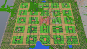
Today we look at that wide band on dark green around the town area in north Seattle. The town center is the red area in the middle, where North Seattle College is. Directly to the northeast is Northgate Mall, and the light rail and bus hubs are at the corner where they come together.
Now that you’re re-oriented, some measurements. Each village (the 24 green squares) are approximately 625 meters to a side (not quite 0.4 miles), adjusted to fit the nearest roads. If you add the band of farmland around each–dividing each band in half so the villages on each side gets a farm–a village is 800 meters on a side (0.5 miles). That means the whole town is 4000 meters–just shy of 2.5 miles–on a side. Put another way, it’s less than a half marathon to run all the way around. It’s still of a scale that’s comprehensible to many pedestrians, hikers, joggers, and others who aren’t always in their car.
(As a kid, our nearest grocery store and the library were a mile away. Sometimes my friends and I would walk up to the store to get some candy or a book or something and walk back. That’s what walking to the other side of this town would be like. Literally child’s play for the able bodied.)
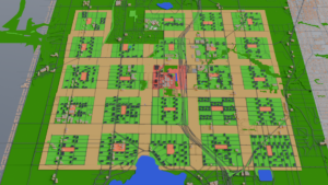
But what is beyond this? The dark green band is 5000 meters on a side, or just about 3 miles. Measuring from the edge of the farmland, the band is 500 meters deep. That’s not quite a third of a mile.
Yes, yes, but what is it?!
Well, speaking of books and child’s play… it’s a deep, dark forest. Well, it’s not that deep, and probably not too dark, but it’s a forest nonetheless. It’s land that is re-wilded. It’s hiking trails, and lakes for fishing. It’s space to forage for mushrooms and berries. For those into natural burials (i.e., returning to the earth without all the trappings of embalming fluid and casket fittings), there may be some areas set aside for people to “compost” themselves. It could, in theory, also be a source of a small amount of sustainable wood for various uses, or have an area for trapping or hunting small game. If the town council decides to allow those uses, of course.
In addition to direct human uses, this area would also help collect and filter rainwater before it makes it back to the Puget Sound, decreasing some flooding risk and decreasing water pollution. Indeed, it would also ease the pressure on biodiversity, giving more species that are more sensitive to urbanization a place to live.
Dealing with the People
There we around 9,000 homes in the green band, or 18,000 individuals. Given the housing assumptions from Phase 1, that’s 27,000 apartment equivalents. Since the denser, Polk-style apartments I’ve used for most of the villages have 54 apartments (we’ll say 50 for easier math), that’s 540 apartment buildings, or 22 or 23 additional buildings per village. That comes out to slightly more than one building per block.
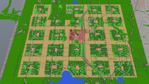
To visually show them, and to provide a little variety, I made a new L-shaped apartment and put forest green on the roof to represent rooftop gardens again. I had to do very little rearrangement of buildings to get 23 “forest people” buildings in each village. One block couldn’t quite fit that many, so I put the few remaining ones in other villages. And since I built 23 in every village, that means there was excess housing of around 400 apartments, which could be dedicated to low-income or transitional housing to give more options for addressing homelessness.
I continued to remove unnecessary roads passing through farmland, and lots of them in the forest. And for good measure, I put a label for each village over the village center for easier reference.
The villages are pretty dense, but all are still low rise residential. They’re all one floor of office/retail space, with two floors of housing. The end. A village could build higher in order to free up more park space if it wanted, but so far the only buildings taller than three floors are in the town center.
In Summation…
The point is this: all that farm land and all that forest land can be freed up if people live more densely, and the emphasis is put on zoning for pedestrians rather than cars. I didn’t doubt that a city built from the ground up could be set up the way Polk’s Edenicity was, but I definitely wasn’t sure an existing city could convert.
However, it wouldn’t take much more than zoning changes to make this a reality. In village areas, require that new construction be low-rise mixed-use. In farm/forest areas, disallow such building and perhaps have some incentive for people or nonprofits to buy up land from those who want to sell and convert it to the new use.
Slowly, over time, policies like this would nudge the city toward what I’ve modeled here. Not as fast as I’ve done it, of course, but based on the real estate numbers I found, most homeowners stay in a house less than 20 years, and most Seattle blocks have about 20 homes. In other words, you could have a conversion rate of about one home into a new use per year. A baby born this year could come home from college to this vision of Seattle: a walkable, solar-powered place where most meals include food grown 3 blocks away, and where you can hang out in a forest by traveling less than 2 miles for everyone.
Oh, wait, wait, wait! Another thought!
Looking back one last time at Polk’s Edenicity plans, he mentions that a town could house 150,000 people. At the densities he uses, that totally works out with what I’ve done here. Seattle’s population is just over 750,000 here in 2024. Doin’ a little math and that would mean all of Seattle could fit in about 5 of these towns.
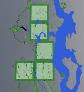
What would that look like? I’ll show you:
The top square is the town I just made. Going south there’s a town for the U-district/Wallingford/Ballard/Fremont area, a Downtown/Capitol Hill town, a SODO/Central Valley/MLK town, and a West Seattle town. All could get this same treatment.
Those living in the aftermath of red-zoning would no longer be in a food desert or suffering the worst of the heat island effect. After all, a farm and a forest are mere blocks away. Transit to the other towns are minutes away.
Some industrial zoning would need to be worked out, of course, as the town plans only included offices in the town centers. And perhaps the Downtown-town could continue to specialize in extra-tall office space since it already has skyscrapers in place. But a lot of Seattle’s industrial is already south of the two southernmost towns, and in that little triangular bit northwest of downtown.
Perhaps these aren’t the best places to put the towns. I don’t know. I’m not an urban planner–I just play one in Blender. But what this has shown me is that there is a lot of room to play with.
Imagine what could be done with the bulk of the land that isn’t in one of the villages. Returned to nature? Returned to descendants of the Native Americans whose land this was when Europeans took it? Solar and wind farms for even more renewable energy?
Whatever it is, I like that the math works out. This kind of a city is possible. We just need to make choices that move in this direction. Pass pedestrian- and bike-friendly traffic and road-building policies. Lean into mixed-use buildings with community parks and away from fenced-off private yards. Require new construction to include a solar or green roof. De-emphasize single-occupancy cars in favor of a more robust bus-and-rail networks.
We can do it.


